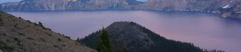
Earth's Shadow & Belt of Venus, Crater Lake, Oregon
Imaged by Steve Kluge (Geosciences
site)
"After several days of incredibly clear, dry weather
in late July, 2004, my family and I were treated to this spectacular
evening view across Crater Lake in southern Oregon. About 7000 years
ago, Mt. Mazama, one of the Cascade volcanos formed by melting in the
subduction zone that underlies the Pacific Northwest, collapsed in
a catastrophic eruption leaving the caldera that's today occupied by
Crater Lake.
Crater Lake is remarkable in several regards: it is deep - 594
m (1,949 ft) at it's deepest, quite clear, it has no inlets or surface
outlets - precipitation is balanced almost perfectly by evaporation
and whatever seeps into the earth under the lake, and it's remarkably
blue.
This photo was taken looking east as the Sun set behind us. Mt.
Scott, on the western flank of the 'crater' (left of center on the
horizon) is an old volcano (450,000 or so years old) that forms the
oldest rocks in the Park. Wizard Island, a more recent
cinder cone, dominates the foreground." Image ©Steve Kluge, shown
with permission.
|